Tag: McDowell Mountain Park (page 42 of 46)

Friday Fitness Hike

This week’s hike was at the North Trail.  Linda, Janet, Nancy, and I hiked the North Trail to the Chuparosa and then out on Pemberton for a ways before returning.  Amy lead Richard, Lynn, and Deb on a hike of the North Trail.

I forgot to check the aperture of my camera; when I got home I noticed that I had it set at f/1.8 for the wide angle focal length.  For the shots where I zoomed in a bit, the aperture was somewhat smaller, but still not small enough to get a decent depth of field.  As a consequence, this week’s photos are not as sharp as usual.

I thought it cool that I was able to get the moon in this photo:

I think the shallow depth of field in this photo helps to isolate the two saguaros in the foregound.  This one ended up being f/3.2 at 1/2000 sec, ISO 125.

We saw these two equestrians riding in on the 150th Street access trail as we were headed back on the Pemberton:

Friday Fitness Hike

Last Friday’s hike started at the Dixie Mine Trailhead at the end of Golden Eagle Blvd.  We hiked out Dixie Mine until we came to the Sonoran Trail.  We hiked Sonoran until it ended at the Promenade Trail.  We took the Promenade Trail a short ways further and then took the Western Loop Trail up to the overlook at the top of the hill.  After a short break, we continued on the Western Loop Trail, which lead us back to the Promenade.  On the way down, we noticed another trail, the Overlook Trail, that none of us had hiked yet.  It wasn’t very far away, so we hiked it too.  We returned via the Promenade, Sonoran, and Dixie Mine trails.

Seven of us hiked on Friday, John, Amy, Lynn, Janet, Bill, Bob, and myself.  (I’m not in the picture this week…)  Bob, Janet and I hiked over eleven miles.  Amy turned around to hike back with John and Lynn at the three mile point.  Bill hiked out to the start of the Western Loop Trail with us and then continued on a ways on the Promenade Trail before turning around.

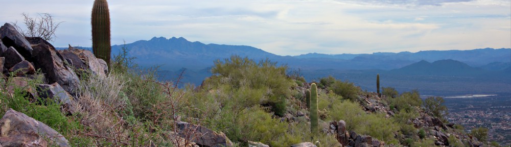
A view of Four Peaks from the Sonoran Trail:


Bob and Janet at the overlook accessible from the Western Loop Trail.  (This is different from the Overlook Trail which we hiked later.)

A view of some of the McDowells from the Western Loop Trail Overlook:

We saw many more saguaros and other cacti as we descended the Western Loop Trail on the other side of the hill.

Part way down the Western Loop Trail, at the Adero Canyon Overlook, is a bench upon which to rest.  None of us needed rest, I guess, because none of us sat down on it.

I saw this boulder a short ways further down the trail.  Four Peaks in the the background:

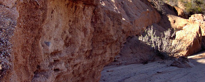
We saw this rock outcropping on the Western Loop Trail, somewhat before it rejoined the Promenade Trail.

We proceeded on to the Overlook Trail and stopped briefly to climb a rock pile. I took this photo of Janet from the top.  (It wasn’t a very big rock pile.)

We saw yet another rock pile as we hiked the Overlook Trail.  It’s a very scenic trail, but you have to have to hike perhaps four and a half miles from where we started to get to it.  I would guess that it’s closer to the other access point that the town has planned.  (I’ve never started from that access point, so I don’t know for certain.)

A view of (and from) the Promenade Trail.  It’s actually an old jeep road which can be seen on the hillside from many places in Fountain HIlls.  (I used to run on part of this road many, many years ago.)

Bob and Janet hike up the section of the Sonoran trail with the longest, most sustained, amount of vertical ascent on the way back.  (There are longer uphill sections on the way out.)

Saguaros along the Sonoran Trail:

A view of Fountain Hills from the Sonoran Trail:


Friday Fitness Hike

Today’s hike started from the Wagner Trailhead.  We hiked Wagner to Granite, turned right and hiked along Granite until we hit the new Lariat Trail.  We hiked out on Lariat until the two mile point was reached for the hike.  At that point, Amy and the short hike group turned around.  The long hike group, me, Bob, Janet, Linda, Amy, and Steve continued on the newly made Lariat Trail until it ran into a new branch of the Pemberton Trail.  There was a small barricade at the intersection warning us not to go west because the trail wasn’t finished yet.  We turned east and followed this new portion of the Pemberton until we got to the 150th street access trail.  Beyond that point, this new branch of the Pemberton was even less constructed than the part that lead west at the Lariat intersection.  We followed the 150th Street Access Trail until it intersected service road, which is the old branch of the Pemberton.  From there we headed west on the road and then south where it turns.  We continued on until we got to the Granite Tank area.

Our intention here was to take the Delsie Trail back to the Granite, but we inadvertently hiked a bit of the new stretch of Pemberton instead.  Once we realized our mistake, we backtracked, got on the Delsie Trail and used it to get back to Granite, at which point we just retraced (most of) our steps back to the Trailhead.  We hiked a total of 10.8 miles today.

Amy points the way to the new Lariat Trail:

We had a big group out for the hike today.  I sort of appear in this photo twice – the photographer’s shadow also belongs to me.  From left to right are me, Amy, Bob, Bill, Steve, Richard, Patricia, Linda, Janet, Nancy, Stephanie, and Roger.

A view of and from the Lariat Trail:

Amy takes her own photo of the area:

A view from the new extension of the 150th Street Access Trail:

A view from the (old) Pemberton as we were nearing the Granite Tank:

A new section of Pemberton as seen from the Delsie Trail.

Saguaros on the Delsie Trail:

Friday Fitness Hike

Seven of us met at the Trailhead Staging Area for Friday’s hike: me, Bill, Janet, Amy, Lynn, Bob, and Bob’s dog, Sarge.  Sarge is appropriately named; he kept us moving at a brisk pace just as a drill sergeant would.  We hiked Pemberton to the pond and then continued on past the pond where we took a large feeder wash over to Stoneman Wash.  We continued on Stoneman Wash through the area of the competitive tracks.  We crossed the main park road and continued our hike up Shallmo Wash, skirted the edge of the horse staging area, hiked the new trail to the Scenic Trail.  We finished our hike on Scenic and a very short section of Pemberton.

In this group photo, below, from left to right, are Janet, Lynn, Bill, Amy, Sarge, and Bob.  We were on the Pemberton at a wash crossing.  Janet, Bob, Sarge, and I hiked that wash down to Stoneman Wash.

Stoneman Wash:

Sarge, on the move:

Sarge allowed me to stop just long enough to take a photo of this unusual saguaro.  At some point in its development, the main trunk split into two parts.

Here’s a crop showing the split and the portions above the split.  It appears that, above the split, the saguaro was even confused about which way to grow the ridges that are normally (roughly) parallel to each other.

Bob with Sarge:

Bob, Sarge, and Janet in Shallmo Wash, just after passing through a tunnel under the road for the horse staging area.

Shallmo Wash:


Friday Fitness Hike

Today’s hike was a loop comprising the Pemberton and Scenic Trail.  Once that portion of the hike was done, some of us went up the wash off the Tonto Tank Trail to look at some of the small canyons in that area.  Amy, Bob, Janet, Nick, Linda, Marilyn, Lynn, Mary Lou, Daniel, and Valerie showed up for the hike today.  That’s eleven of us (counting me too).

Nick shows off his new stick made from a portion of an agave stalk.  This was the same stick he found and used to negotiate the Barnhardt Trail several weeks ago.  Different ornaments may be affixed to the top of the staff.

Erosion in one of the washes created this interesting formation:

We saw this owl during our exploration of the area.  I had to crop the image significantly to get this picture.  (The RX100  used to take this photo has a very limited zoom.)

More views from the wash:

When we got back, we saw a group of equestrians preparing for a trail ride.


Friday Hike at the Tom’s Thumb Trailhead

Friday’s Hike wasn’t an official Fitness Hike scheduled at McDowell Mountain Park, but five of us met at the Tom’s Thumb Trailhead just off of 128th Street.  Bob, Bob’s dog Sarge, Linda, Nick, and I hiked the Marcus Landslide Trail, including the short loop at the end.  After hiking the loop on the Marcus Landslide Trail, we backtracked to the intersection with the Boulder Trail and took Boulder down to the Pemberton.  From there, we hiked over to Coachwhip and turned off on the Windmill Trail.  We took the East End Trail up to the Tom’s Thumb Trail, which took us most of the way back to the parking lot.  We made a slight diversion near the end in order to make our hike just slightly longer than twelve miles.

A pair of rocks near the Sven Slab climbing area:

A saguaro on the Marcus Landslide Trail:

Another view from the Marcus Landslide Trail:

A broken mushroom rock leaning against another rock.  I managed to avoid getting the sign in the photo by standing right behind the sign while taking this photo.  (I took another photo of this rock formation on a hike back in November.  On that occasion, I had Nancy stand in front of the sign.)

Another mushroom shaped rock:

Bob’s dog, Sarge:

Submarine Rock:

Beneath Submarine Rock:

Bob, Sarge, Linda, and Nick on the Coachwhip Trail:

Looking up at a few of the many switchbacks on the East End Trail:

Views from the East End Trail:

Linda, Nick, and Bob near the top of the East End Trail:

Linda takes a break while Nick explores the nearby cave / shelter:

The cave / shelter:

Below are some signs on the Tom’s Thumb Trail.  Joe and I climbed at Fort McDowell one time, but I haven’t been any further on this trail.  Back in the ’90s, Marilyn and I tried to find the other climbing areas, but there weren’t decent trails to these areas back then. (None that I could find, anyway.) According to the map, this trail should lead all the way to Tom’s Thumb.  I think it’d be fun to try to get to Tom’s Thumb via the Fort McDowell / Lost Wall / Half and Half Wall access trail.


Friday Fitness Hike

Today’s hike started at the Wagner Trailhead.  We went out Wagner, turned right on Granite, and turned up Delsie.  We then made our way back on Stoneman Wash and retraced our steps back to the trailhead.  We had a small group today, just me, Bob, Janet, Amy, and Lynn.  It had rained overnight and, although we got rained on a bit during our hike, it was clear most of the way.  The trails were very spongy though.

We saw these saguaros just off the Delsie Trail:

Amy holds up a horseshoe that she found in Stoneman Wash:

A mushroom shaped rock near Stoneman Wash:

Janet, Lynn, and Amy finish hiking Stoneman Wash:

A Hedgehog Cactus off the Wagner Trail:


Friday Fitness Hike

Friday’s hike started at the Trailhead Staging Area.  Eleven of us hiked the Scenic Trail and then a smaller group of us hiked out to the site of the ranch homestead.  We finished up by hiking back on part of Stoneman Wash.

Below is a group photo.  (There were too many new names for me to remember…)

Ranger Amy tells the group about a petroglyph that can be seen along the Scenic Trail:

Amy and Nick lead the way along the Scenic Trail:

A coil of barbed wire and a fence post remind us that the area was once a ranch:

The steep bank of a wash near the old homestead:

This clay pit (below) is just off the Pemberton Trail somewhat past the site of the old homestead.  I’ve been told that clay was mined here for a short period of time with the intent of making clay water pipes.  If it weren’t for the invention of PVC pipe, the area might have been very heavily mined for clay.

Four Peaks can be seen in the distance.

We saw some Desert Broom flowers that had gone to seed in some of the washes:

Hiking down one of the feeders to Stoneman Wash:

Hiking up a short, but steep hill leading out of Stoneman Wash:

The arrow points at Nancy:

Two of our hiking group with the McDowells in the background:


Friday Fitness Hike

Bob, Janet, Linda, Nancy, and I met at 7:30am, half an hour early, in order to give ourselves enough time to do a long hike with a significant amount of elevation change.  A 7:00am start might have been even better.

We hiked out Dixie Mine to the mine, passed the petroglyphs, and continued up the wash until we hit the Prospector Trail.  We took Prospector up to the Bell Pass Trail and then hiked up to Bell Pass.  After looking at the views afforded by our vantage point at Bell Pass, we turned around and hiked the Bell Pass Trail to the Windmill Trail.  We stopped at the windmill and spent some time looking around that area.  We continued on Windmill until it ended at Coachwhip. Coachwhip took us back to the Dixie Mine Trail, which, in turn, took us back to our vehicles.  We hiked twelve miles with over 1700 feet of total ascent.

Bob pointed out this bright field of quartz on the Dixie Mine Trail:

Linda takes photos of the petroglyphs near the mine, while Janet looks on:

Petroglyphs:

Linda hikes up the smooth and slippery rock of the (dry) waterfall while Nancy and Bob negotiate the bottom section.  It’s not really as far down as it looks in this photo; it’s an illusion created by the wide angle lens I was using.  If you look to the far left, you can see another petroglyph.

This is what it looked like from the bottom:

Linda, Janet, Bob, and Nancy slightly past the waterfall area.

Saguaros on the Prospector Trail.   The saguaros are “leaning” due to the fact that I was pointing the wide angle lens slightly upward.  I had thought about trying to correct the lean in post processing, but Marie convinced me that the photo looked cooler left alone.

The windmill, for which the Windmill Trail was named:

This large cottonwood is near the windmill.  It makes for a better landmark than the windmill itself since the windmill can be kind of hard to see from the Windmill Trail.

Another view of the cottonwood and the bullet-ridden storage tank:

Looking up through the dead tree at the right in the previous photo:

A view from the Coachwhip Trail.

Another view from further down the Coachwhip Trail:

Bob, Janet, and Linda pass the turnoff to the mine on the way back:

Friday Fitness Hike

Friday’s hike started at the Wagner Trailhead.  Amy had the day off due to the Thanksgiving day holiday.  Susan Davis lead the short hike in her place.

Eleven of us started from Wagner Trailhead.  We hiked Wagner to Granite and then Granite to the Delsie Trail.  At that point, we split up.  Sue took her group up to the Bluff and then back to the trailhead making for a four to five mile hike depending upon the exact route back to the trailhead.

The long hike group, me, Marilyn, Bob, Janet, Alan, Nancy, and Linda, hiked the Deslie to Pemberton.  We then hiked over to one of the Stoneman Wash feeder washes which lead to Stoneman Wash.  We saw horse tracks in the feeder wash, but smaller tracks too and sign of activity under some of the brush along the way.  Stoneman Wash was quite the slog as it had been churned up by the equestrian event from a week earlier.

When we got back to the Granite Trail, we took it back to Wagner and then back to our cars, making for a nine mile hike.

Group photo:

A saguaro on the Delsie Trail:

Bob and Alan take a short break at the new picnic table and shelter near Granite Tank:

One of the views while hiking to Stoneman Wash: