Tag: Fountain Hills (page 1 of 6)

Bush Fire from Fountain Hills

Marilyn, Marie, and I went for an evening walk on Saturday, the 13th.  Marilyn noticed a reddish glow in the distance; we walked up a nearby hill to see better.  We saw an orange glow in the distance, behind some hills.  When we concluded our walk, I brought my camera out to get this photo.  It was much less bright than shown in my photo below; actually, at the time we were there, it was less bright than earlier in the evening.

On the ten O’clock news we learned that it’s called the Bush Fire, it’s in the Tonto National Forest, and that traffic has been blocked of on SR 87 (Beeline Hwy).

Update – 2020-06-14:

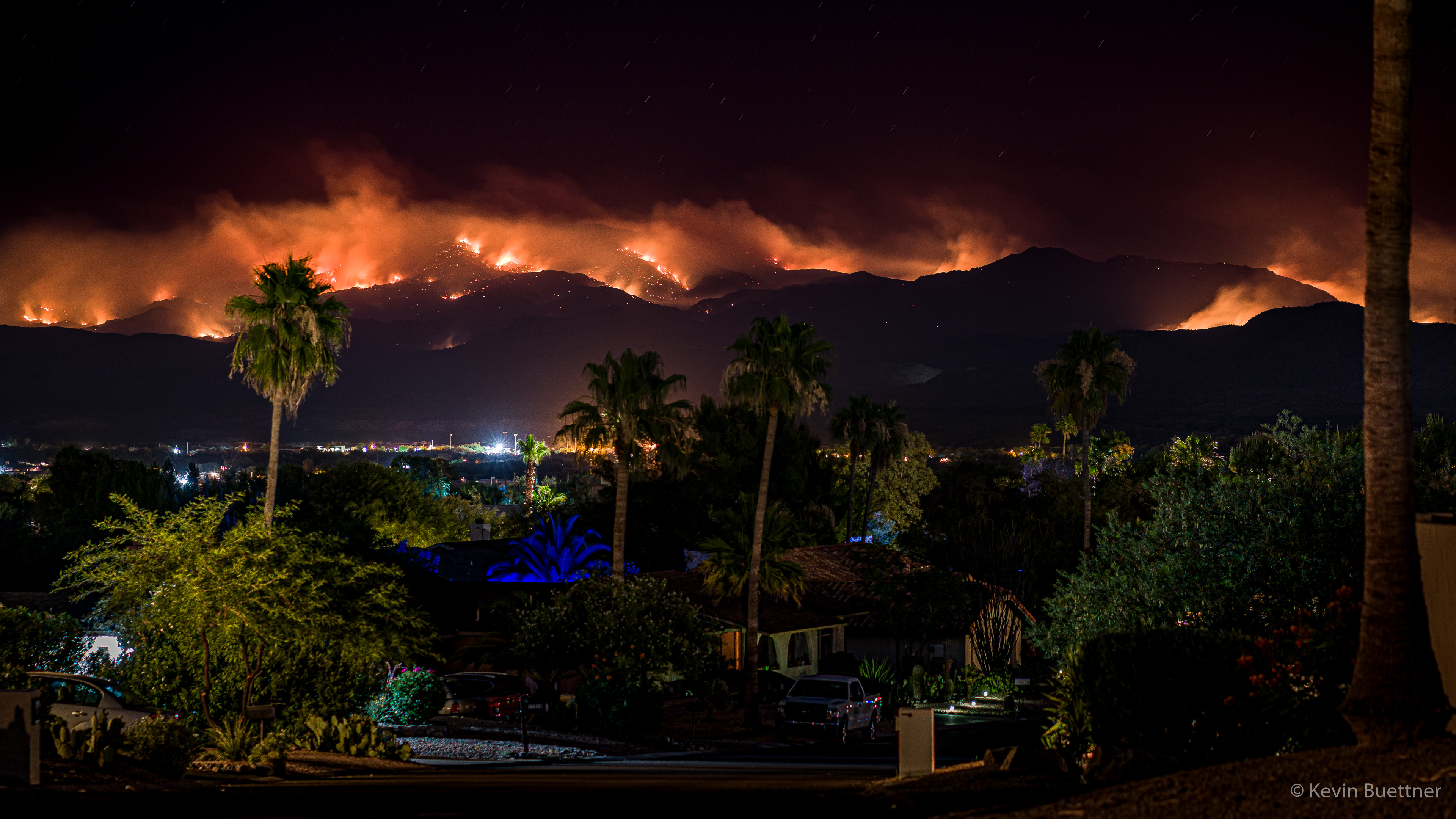
Marilyn and I went out for another walk, shortly after 8:00pm on Sunday, the 14th.  We first walked up to the top of the hill where I had taken the earlier photo. We returned by walking down the street upon which we lived.  At the top of the street (which is on a hill), we found quite a dramatic view…

Update – 2020-06-15:

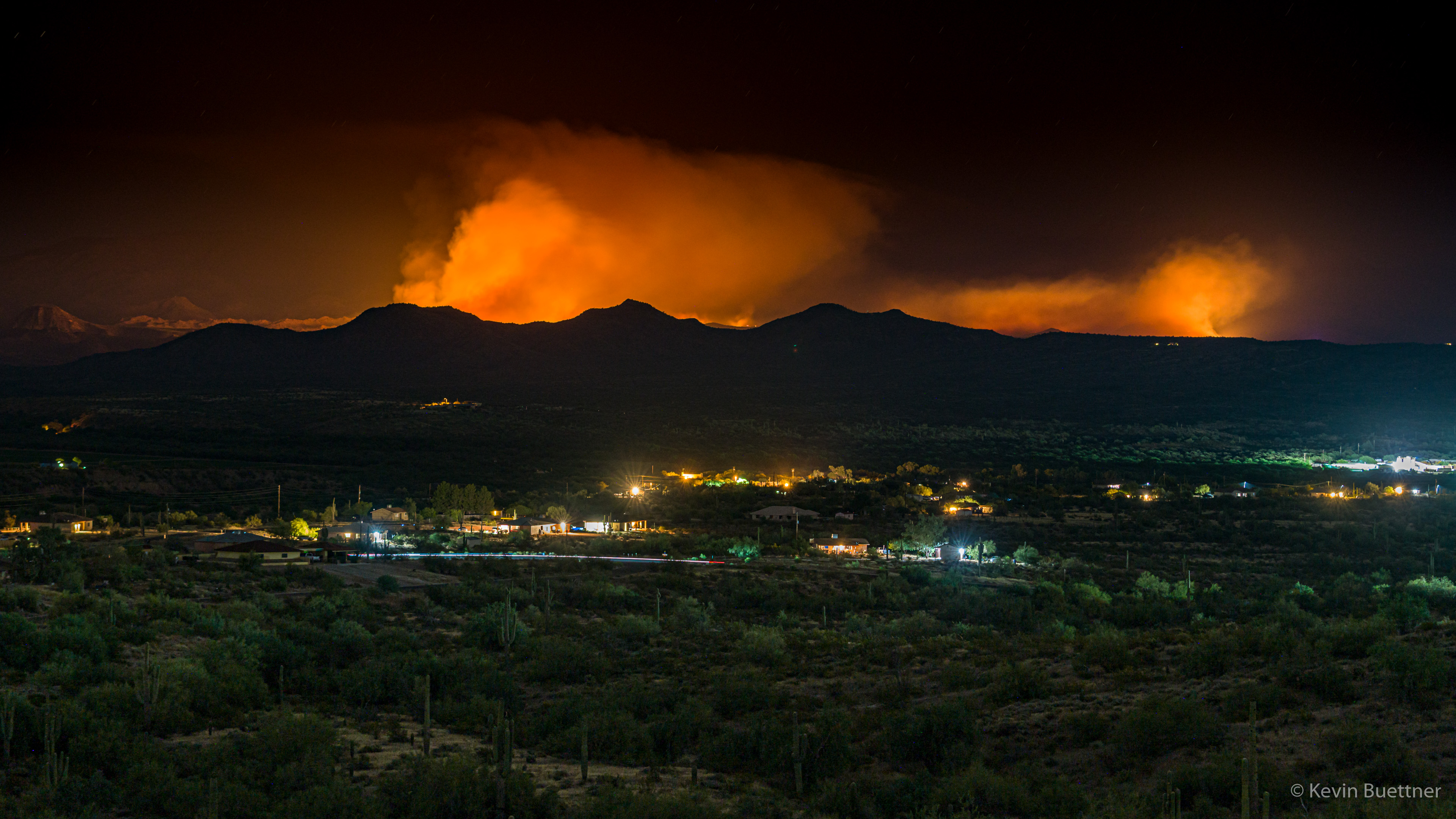
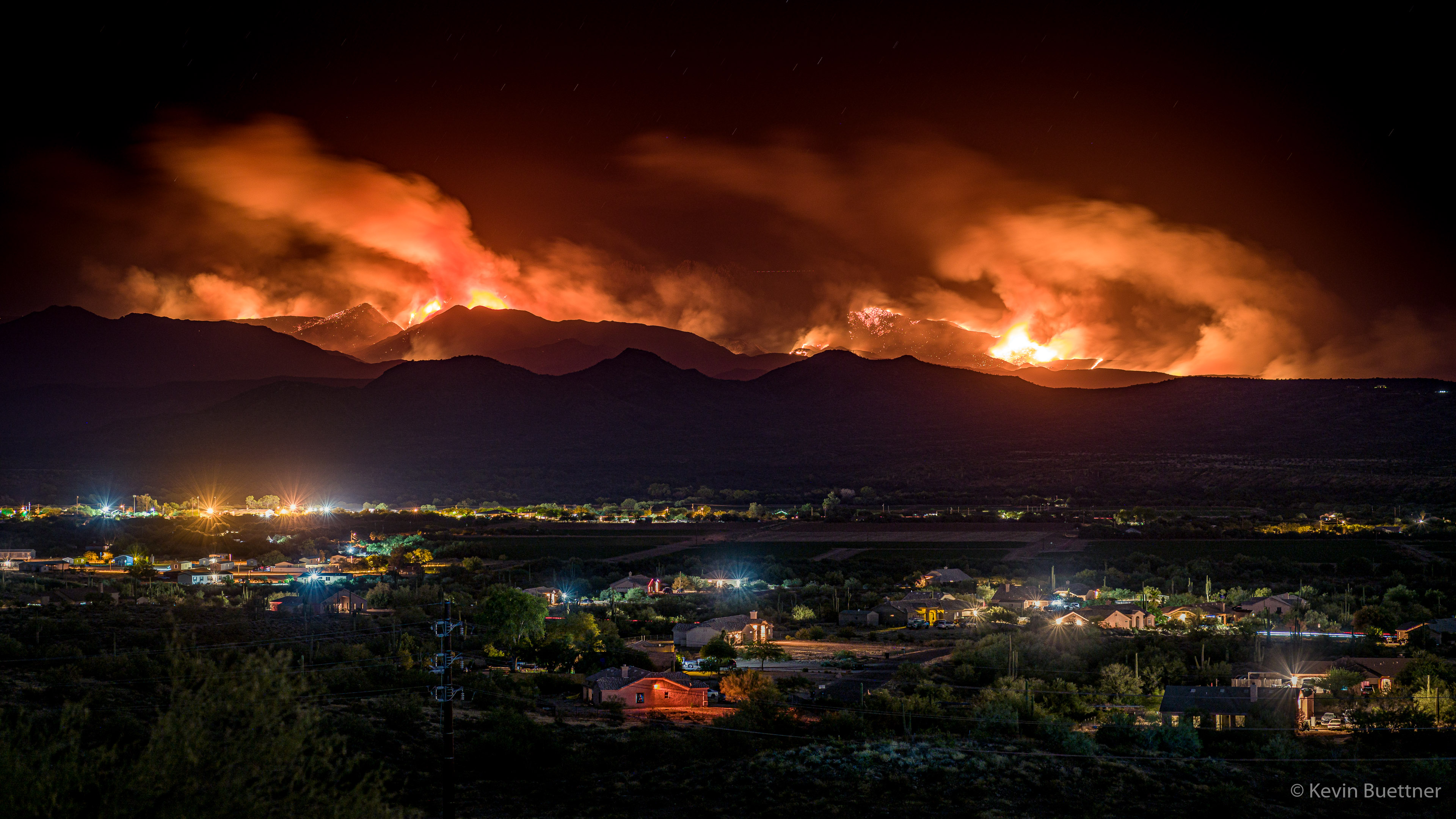
On the evening of Monday, the 15th, I walked across McDowell Mountain Road, hiked up one of the hills to the north, and took some more photos.  According to InciWeb, on Monday evening, the Bush Fire is 37,900 acres in size and is still 0% contained.

Remember, this is a long exposure; this scene did not appear this bright while I was there. I was able to see some lights on the Fort McDowell Yavapai Nation, I certainly wasn’t able to see this community in the level of detail shown here – it was much too dark. Likewise, the smoke didn’t have much of the color or glow shown in this photo; that too is due to taking a long exposure.

Update – 2020-06-16:

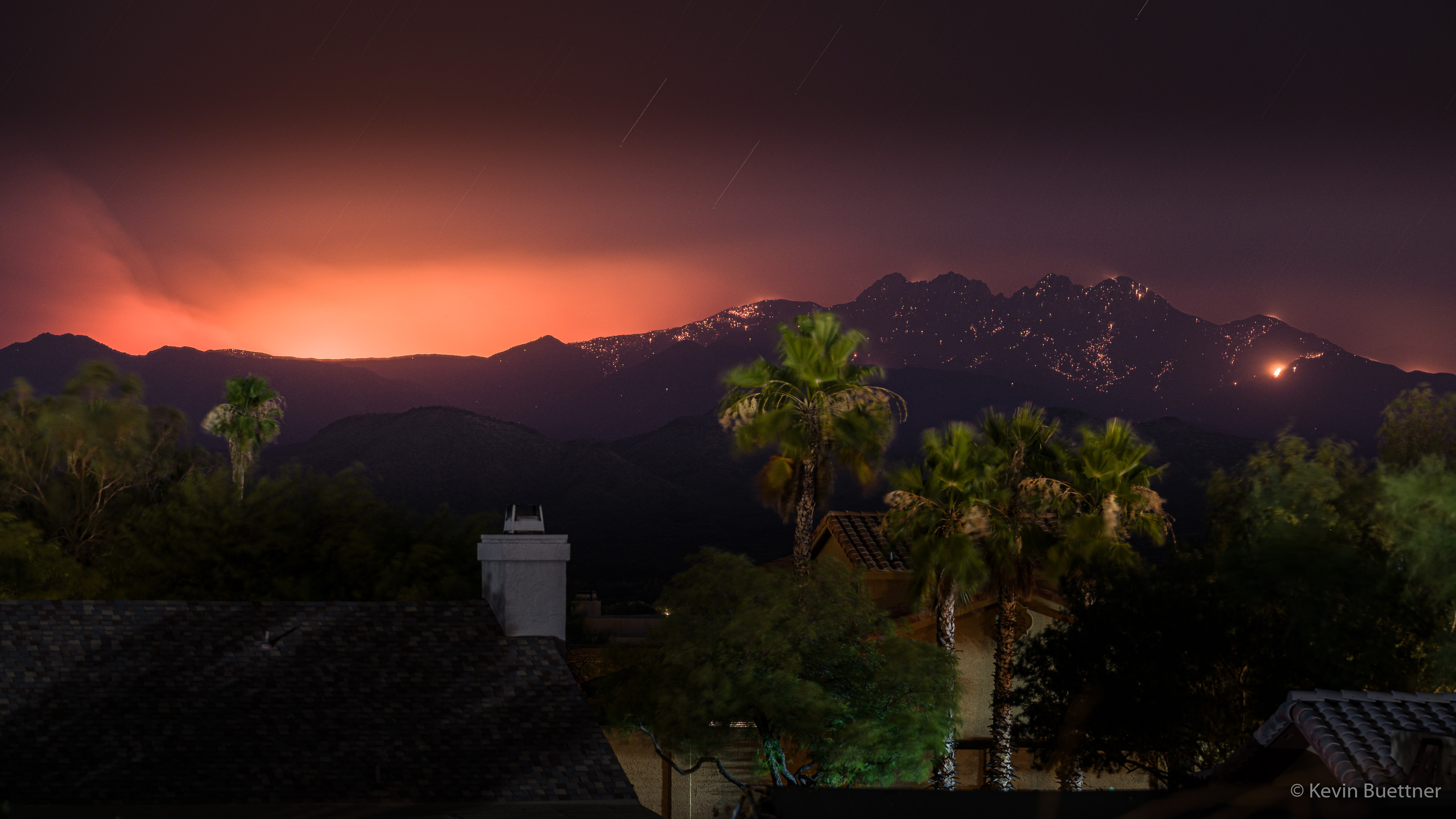
According to InciWeb, the Bush Fire grew to 64,513 acres in size, still with 0% containment. However, when I went out on my balcony in the evening to look, I saw only a faint glow in several areas. That being the case, I decided against going somewhere to take a photo and instead just took a shot from my balcony. Although my eyes couldn’t see much activity in the distance, a three and half minute exposure picked up a lot of hot spots on Four Peaks in addition to the usual glow in the smoke. I think that the long exposure smoothed out the smoke in addition to making the trees appear out of focus – they’re not out of focus; it’s just motion blur.

Wednesday Night Hike

Nine miles on Wednesday night; I somewhat reversed the route that I had been taking and (re)explored some paths that I hadn’t been on in over twenty years.

These photos were from early in the hike.  I got slightly lost midway through and got home well after dark.

Tuesday Night Hike

I hiked a little over seven miles on Tuesday night.

Friday Fitness Hike

Jude, Nora, Sara, Marilyn, Bob, and I hiked 8 miles on the Dixie Mine and Sonoran Trails. Total ascent was just over 1400 feet.

All of the photos below were taken from the Sonoran Trail.

We were most impressed by this mountain biker. The terrain here is steeper than it looks; plus, she had just negotiated a fairly tight switchback. She managed to pass us on this narrow trail without dismounting.

Looking towards Fountain Hills and the Superstition Wilderness…

Friday Fitness Hike

Kathy, Jerry, Mike, Nancy, Bill, Heather, Bob, and I did a 10.2 mile hike on Friday.  We hiked Dixie Mine to Sonoran and then did a loop on the Western Loop Trail.  On the way back, Bill showed us the trail that he and his crew have been building.  Tentatively called the Lower Sonoran Trail, it uses some of the lower portions of the slope below the current Sonoran Trail, running from the Promenade Trail to Sonoran Trail at the boundary between the park and the preserve.  Bill told me that the current Sonoran Trail between those two points is 1.8 miles in length; the new section of trail is 2.1 miles long. In most instances, I prefer hiking a loop instead of a pure out-and-back, so having a new and scenic option in the area is much appreciated.

Mike (far left), Bob, Jerry, Nancy, and Heather on the Sonoran Trail:

Ocotillos on the Sonoran Trail:

Nancy and Kathy hiking up the Western Loop Trail:

A view from just below the overlook:

Heather at the top of the overlook just off the Western Loop Trail:

Mike (above left), Nancy, Bill, and Heather descending the Western Loop Trail:

Nancy, Bill, and Heather:

The new section of trail has lots of ocotillos too!

Bill on the new section of trail:

Heather and Nancy taking a break…


Backlit Desert

This is a view from the Dixie Mine Trail on late Sunday afternoon.

20151011-_DSC3276-Edit-medium

Crested Saguaro

20151011-_DSC3446-HDR-Edit-medium

Fountain Hills Botanical Garden

On Saturday, Marilyn and I walked the trails in the Fountain Hills Botanical Garden.

20150516-_DSC3886-Edit-medium 20150516-_DSC3900-Edit-medium 20150516-_DSC3923-Edit-medium 20150516-_DSC3947-Edit-medium 20150516-_DSC3956-Edit-medium 20150516-_DSC3998-Edit-medium 20150516-_DSC4007-Edit-medium 20150516-_DSC4013-Edit-medium 20150516-_DSC4013-Edit-medium-2


Second Mesa Maiden

20150509-_DSC3665-Edit-medium

20150509-_DSC3662-Edit-medium

Friday Fitness Hike

Last Friday’s hike started at the Dixie Mine Trailhead. We hiked Dixie Mine to Sonoran and took Sonoran until it joined with the Promenade Trail. At that point, Linda, Janet, Charles, Angel, and Marilyn turned back for a 7.8 mile hike. Bob and I continued on. We hiked up the Western Loop Trail, stopped briefly at the overlook and then continued on down the Western Loop Trail. We then took the recently constructed Andrews-Kinsey Trail to the Sunrise Trail. We hiked to the top of Sunrise Peak and then returned to the Fountain Hills side by retracing our steps on the Andrews-Kinsey Trail. Altogether, we hiked a little over 15 miles with 2800 feet of total ascent.

This is a view from the Sonoran Trail, somewhat before reaching the Preserve.

20141128-_DSC6472-Edit-2-medium

A view from the Western Loop Overlook:

20141128-_DSC6505-Edit-2-medium

This is another view from the Western Loop Overlook. The Andrews-Kinsey Trail is visible in this photo.

20141128-_DSC6511-Edit-medium

We saw some Brittlebush in bloom, which is kind of unusual for this time of the year.

20141128-_DSC6541-Edit-2-medium

A saguaro on the Andrews-Kinsey Trail:

20141128-_DSC6571_2_2_3-Edit-2-medium-2

A barrel cactus on the Andrews-Kinsey Trail:

20141128-_DSC6595-Edit-2-medium

It was crowded on top of Sunrise Peak:

20141128-_DSC6607-Edit-2-medium

This dog was able to drink directly from a water bottle! It didn’t spill much either.

20141128-_DSC6616-Edit-medium

Yet another view from Sunrise Peak:

20141128-_DSC6622-Edit-2-medium

This is a view of Fountain Hills as we were descending Sunrise Peak.

20141128-_DSC6631-Edit-2-medium-2


I noticed this rock outcropping on the way back.

20141128-_DSC6646-Edit-2-medium

Another view, from the other side, of the saguaro that we saw earlier in the hike.

20141128-_DSC6661-Edit-medium

More saguaros on the Andrews-Kinsey Trail:

20141128-_DSC6666-Edit-medium