
Month: January 2013 (page 1 of 1)
Last Friday’s hike started at the Dixie Mine Trailhead at the end of Golden Eagle Blvd. We hiked out Dixie Mine until we came to the Sonoran Trail. We hiked Sonoran until it ended at the Promenade Trail. We took the Promenade Trail a short ways further and then took the Western Loop Trail up to the overlook at the top of the hill. After a short break, we continued on the Western Loop Trail, which lead us back to the Promenade. On the way down, we noticed another trail, the Overlook Trail, that none of us had hiked yet. It wasn’t very far away, so we hiked it too. We returned via the Promenade, Sonoran, and Dixie Mine trails.
Seven of us hiked on Friday, John, Amy, Lynn, Janet, Bill, Bob, and myself. (I’m not in the picture this week…) Bob, Janet and I hiked over eleven miles. Amy turned around to hike back with John and Lynn at the three mile point. Bill hiked out to the start of the Western Loop Trail with us and then continued on a ways on the Promenade Trail before turning around.

A view of Four Peaks from the Sonoran Trail:

Bob and Janet at the overlook accessible from the Western Loop Trail. (This is different from the Overlook Trail which we hiked later.)

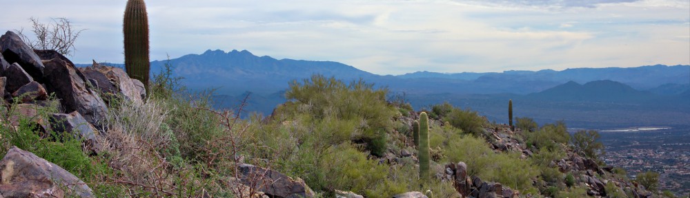
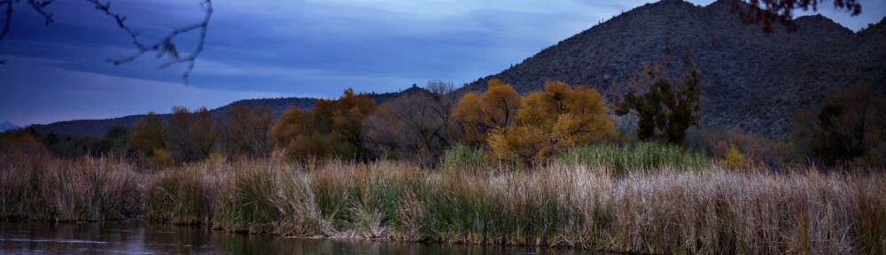
A view of some of the McDowells from the Western Loop Trail Overlook:

We saw many more saguaros and other cacti as we descended the Western Loop Trail on the other side of the hill.

Part way down the Western Loop Trail, at the Adero Canyon Overlook, is a bench upon which to rest. None of us needed rest, I guess, because none of us sat down on it.

I saw this boulder a short ways further down the trail. Four Peaks in the the background:

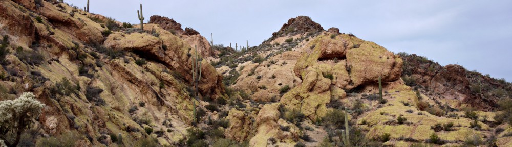
We saw this rock outcropping on the Western Loop Trail, somewhat before it rejoined the Promenade Trail.

We proceeded on to the Overlook Trail and stopped briefly to climb a rock pile. I took this photo of Janet from the top. (It wasn’t a very big rock pile.)

We saw yet another rock pile as we hiked the Overlook Trail. It’s a very scenic trail, but you have to have to hike perhaps four and a half miles from where we started to get to it. I would guess that it’s closer to the other access point that the town has planned. (I’ve never started from that access point, so I don’t know for certain.)

A view of (and from) the Promenade Trail. It’s actually an old jeep road which can be seen on the hillside from many places in Fountain HIlls. (I used to run on part of this road many, many years ago.)

Bob and Janet hike up the section of the Sonoran trail with the longest, most sustained, amount of vertical ascent on the way back. (There are longer uphill sections on the way out.)

Saguaros along the Sonoran Trail:

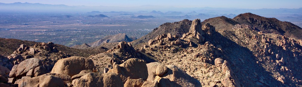
A view of Fountain Hills from the Sonoran Trail:

Marilyn, Joe, and I hiked the Butcher Jones Trail near Saguaro Lake last Saturday. The trail follows the contours of the Saguaro Lake shoreline for much of its length.
The trail is wide with touristy informational signs at the beginning.

A view of a section of beach and a cliff near the parking area:

Another view of the lake and its rugged shoreline.

Waterfowl in the lake and a hillside full of saguaros and other desert vegetation. If you look closely, you can see the trail following the lower contours of the hill.

We saw a lot of boats on the water during our hike…

A view of Four Peaks:

The view kept changing slightly as we hiked. Here’s another view of the cliff and hills along the lake.

A look back at where we had started. Butcher Jones Recreation Area, where we parked is at the far left. The trail mostly snakes along the shoreline. It’s visible in several places in this photo. A 4WD drive road is also visible in this photo.

We came to a place were we could see the Flatiron in the Superstitions framed by the canyon walls of the lake.

I got out my tripod and zoom lens for this shot:

A view of Four Peaks with Burro Cove in the foreground:

Another look at the Flatiron on the way back…

Joe, hiking ahead of me somewhat before sunset:

The setting sun gave Four Peaks an orange-pink glow:

Another photo taken just before sunset:

Saguaro silhouettes:

Fishing at sunset:

I took this photo from the beach of the Butcher Jones Recreation Site, just before leaving:

Today’s hike started from the Wagner Trailhead. We hiked Wagner to Granite, turned right and hiked along Granite until we hit the new Lariat Trail. We hiked out on Lariat until the two mile point was reached for the hike. At that point, Amy and the short hike group turned around. The long hike group, me, Bob, Janet, Linda, Amy, and Steve continued on the newly made Lariat Trail until it ran into a new branch of the Pemberton Trail. There was a small barricade at the intersection warning us not to go west because the trail wasn’t finished yet. We turned east and followed this new portion of the Pemberton until we got to the 150th street access trail. Beyond that point, this new branch of the Pemberton was even less constructed than the part that lead west at the Lariat intersection. We followed the 150th Street Access Trail until it intersected service road, which is the old branch of the Pemberton. From there we headed west on the road and then south where it turns. We continued on until we got to the Granite Tank area.
Our intention here was to take the Delsie Trail back to the Granite, but we inadvertently hiked a bit of the new stretch of Pemberton instead. Once we realized our mistake, we backtracked, got on the Delsie Trail and used it to get back to Granite, at which point we just retraced (most of) our steps back to the Trailhead. We hiked a total of 10.8 miles today.
Amy points the way to the new Lariat Trail:

We had a big group out for the hike today. I sort of appear in this photo twice – the photographer’s shadow also belongs to me. From left to right are me, Amy, Bob, Bill, Steve, Richard, Patricia, Linda, Janet, Nancy, Stephanie, and Roger.

A view of and from the Lariat Trail:

Amy takes her own photo of the area:

A view from the new extension of the 150th Street Access Trail:

A view from the (old) Pemberton as we were nearing the Granite Tank:

A new section of Pemberton as seen from the Delsie Trail.

Saguaros on the Delsie Trail:

On Saturday, January 5, Bob and I did a hike in the McDowell Mountains starting at the Tom’s Thumb Trailhead. We hiked out Mesquite Canyon, taking a climber’s access trail up past the Sven Towers climbing area. We proceeded on to another climbing area known as Hog Heaven. Just above Hog Heaven is a small pinnacle that’s visible from McDowell Mountain Park and even from parts of Fountain Hills. Our goal for the day was to get to that pinnacle. There’s a climb rated 5.5 on that pinnacle named “Thumbnail” so, therefore, I’ll call it the Thumbnail Pinnacle in this post.
In the photo below, the Thumbnail Pinnacle is a third of the way over from the right hand side of the photo. Several walls of the Hog Heaven climbing area are below it.

Another view as we got somewhat closer:

A view to the east and downward from atop a boulder from near the Hog Heaven climbing area. Portions of the Marcus Landslide Trail can be seen at the bottom of the photo. About a third of the way over near the bottom is a large rock called “Submarine Rock”. McDowell Mountain Park is visible above Submarine Rock. Further off in the distance are the communities of Rio Verde and Tonto Verde followed by some mountain ranges whose names I do not know.
It was interesting to look at the full size, 6024×4024 pixel, versioni of this photo. Zoomed in all the way, I was able to locate some of the trails that I either hike or mountain bike regularly in the park.

A view to the southeast of Fountain Hills, Weaver’s Needle, and Red Mountain:

Below are several views of the Thumbnail Pinnacle.


Slightly above the Thumbnail Pinnacle is a view Scottsdale to the west:

We looked up and saw what we thought might be the peak. It turns out that it wasn’t the peak, but the actual peak wasn’t too far away. I thought the line of whitish stones was interesting.

A closer look at those “white” looking stones. Close up, they don’t appear to be white at all, but they are lighter in color than some of the surrounding rock and the ground.

We hiked up to the peak above us. The photo below is a view of the Thumbnail Pinnacle from above. Four Peaks is visible at the left of the photo.

Thompson Peak (with the antennas) to the left and McDowell Peak to the right:

A view of the East End (Peak) with a small weather station below and to the left. It didn’t look all that far away and it seemed that there might be an easier way down off in that direction, so we made our way over to that peak.

On our way over to the East End peak, we looked down and saw the East End Trail with its many switchbacks.

A view into Scottsdale from near East End peak:

The weather station:

A view of Tom’s Thumb and Scottsdale from atop East End Peak. While we were up there, we spotted a lower peak that we decided to bag next.

Bob, atop East End peak:

We saw several USGS markers, below, on a rock adjacent (and slightly lower) than the peak. It appears to me that 4001 has been etched on the marker, but several other sources state that the elevation is 4,067 feet. I think it’s likely that more accurate methods of determining elevation were used sometime after 1968 to determine the height. The rock upon which Bob is standing in the photo above is the highest point in the McDowell range.

Bob took this photo of some Javelina that we saw on the saddle below us as we were descending.

As we descended, both Glass Dome and Tom’s Thumb became visible.

We crossed the saddle where we saw the Javelina and came upon this rock (at the right) which we decided to call Mitten Rock.

A view of another rock formation to the southeast.

Looking down on Gardner’s Wall and Tom’s Thumb:

Bob took this photo of me as we descended further:

A view of Pinnacle Peak and part of Troon. Part of the Tom’s Thumb Trail is also visible in this photo.

Glass Dome and Tom’s Thumb:

Once we intersected the Tom’s Thumb Trail, we hiked over to the intersection with the East End Trail and took another climber’s access trail down past Gardner’s Wall. On the way, we saw this roadrunner, below. Bob took this photo – he had more zoom on the lens of his camera. It’s a much better shot of the roadrunner than any that I took.

A short ways further, we saw this rock, which sort of reminds me of a dinosaur head:

I liked this view of the saguaro standing next to a large boulder only slightly taller than the saguaro:

Seven of us met at the Trailhead Staging Area for Friday’s hike: me, Bill, Janet, Amy, Lynn, Bob, and Bob’s dog, Sarge. Sarge is appropriately named; he kept us moving at a brisk pace just as a drill sergeant would. We hiked Pemberton to the pond and then continued on past the pond where we took a large feeder wash over to Stoneman Wash. We continued on Stoneman Wash through the area of the competitive tracks. We crossed the main park road and continued our hike up Shallmo Wash, skirted the edge of the horse staging area, hiked the new trail to the Scenic Trail. We finished our hike on Scenic and a very short section of Pemberton.
In this group photo, below, from left to right, are Janet, Lynn, Bill, Amy, Sarge, and Bob. We were on the Pemberton at a wash crossing. Janet, Bob, Sarge, and I hiked that wash down to Stoneman Wash.

Stoneman Wash:

Sarge, on the move:

Sarge allowed me to stop just long enough to take a photo of this unusual saguaro. At some point in its development, the main trunk split into two parts.

Here’s a crop showing the split and the portions above the split. It appears that, above the split, the saguaro was even confused about which way to grow the ridges that are normally (roughly) parallel to each other.

Bob with Sarge:

Bob, Sarge, and Janet in Shallmo Wash, just after passing through a tunnel under the road for the horse staging area.

Shallmo Wash:

On Sunday, Marilyn, Joe, Bob, Nick, and I hiked through Rough-N-Ready Canyon. We started on the Javelina Mine Trail which connects to a wash that eventually turns into a good sized canyon. My feet and ankles didn’t much like the numerous loose and rounded stones on the hike, so, on the way back, we bushwhacked over to and returned via the Javelina Mine Trail. Total distance, according to my GPS, was about 9.3 miles. Bob’s phone, on the other hand, showed that we had hiked nearly twelve miles. (Clearly, one of them is wrong.)
Here are the GPS tracks for the day. The light blue track is the track out to the cave. The dark blue track is the track back from the cave to the parking area.
View hike-130106-rough-n-ready.kml in a larger map
Early in the hike, on a narrow, but good trail:

One (of many) rock formations:

Marilyn and Nick in the wash, fairly early on in the hike. It abruptly descended twelve to fifteen feet at this point.

We saw many interesting rock formations along the way. The desert scenery was somewhat different than that to which we are accustomed.


Marilyn with her camera:

The sky became more interesting later in our hike. The rock formations got bigger and even more interesting too.


One of my favorite photos from this hike:

The canyon walls became very steep and very tall.

I had fallen far behind, but I eventually caught up with the others.

They were waiting by a cave which has two openings.

The interior of the cave:

Marilyn, hiking ahead of me on the way back:

A view after we exited the canyon:

Taking a break on lichen covered rock:

Views from the Javelina Mine Trail as evening approaches:


Bonus photos from Marilyn!


Today’s hike was a loop comprising the Pemberton and Scenic Trail. Once that portion of the hike was done, some of us went up the wash off the Tonto Tank Trail to look at some of the small canyons in that area. Amy, Bob, Janet, Nick, Linda, Marilyn, Lynn, Mary Lou, Daniel, and Valerie showed up for the hike today. That’s eleven of us (counting me too).
Nick shows off his new stick made from a portion of an agave stalk. This was the same stick he found and used to negotiate the Barnhardt Trail several weeks ago. Different ornaments may be affixed to the top of the staff.

Erosion in one of the washes created this interesting formation:

We saw this owl during our exploration of the area. I had to crop the image significantly to get this picture. (The RX100 used to take this photo has a very limited zoom.)

More views from the wash:


When we got back, we saw a group of equestrians preparing for a trail ride.

On Sunday, Marilyn, Joe, Nick, and I hiked out near Saguaro Lake. We did the Goldfield High Country via Gateway Canyon hike. This hike is supposed to be only eight miles in length and, if you manage to do it efficiently without any wrong turns or detours, it might actually turn out to be that long. We, however, ended up hiking 9.72 miles with 1,219 feet of total ascent.
There is a maze of trails in the area. If you are thinking about doing this hike, I strongly recommend downloading one of the GPS tracks from the page describing this hike at hikearizona.com. I downloaded johnr1’s Official Route to my GPS. We probably would not have found our way had we not had these GPS tracks. There are so many trails in the area that it is easy to make a wrong turn or miss a turn. There were several instances where we got off route even with the track. Yours truly even hiked a bit over a quarter mile on what seemed to be a good track certain that it would eventually turn and go the right way. It was, in fact, going almost exactly the wrong way from where we wanted to go.
We started out in the early afternoon on Sunday, but it got dark on the way back. We all ended up strapping on our headlamps so that we could see the trail during the last couple of miles.
The hike parallels the river for the first couple of miles. At times, the river is in sight; at other times it’s far enough way that it can’t be seen. We felt like we were zigzagging our way along this entire stretch. One of the most difficult parts for me was the sections of river rock. I don’t move well through this type of terrain due to old injuries.

We eventually entered a wash with steep walls. I found the hiking to be much easier here. The sand underfoot was firm and even. No more ducking under low hanging limbs through the maze of small trees or hiking on ankle-turning river rock.

Marilyn stops to take her own photos in this wash:

A view of the canyon where the majority of the elevation gain occurs. There is a trail (not visible in the photo below) along the left canyon wall leading up to the top. On the way up, we made the constant mistake of following right offshoots of the trail. We’d proceed for a ways on what appeared to be a trail only to have it peter out. We would then notice a good trail 10 or so feet higher up to our left.

We saw several caves in the canyon walls on the way up.

This fin on the canyon wall reminded us of some of the canyon country in Utah:

Joe pauses so that I can get a photo on the way up:

It was a cloudy day on Sunday. The sun barely manages to peek through the clouds behind another wall that we saw after we emerged from the canyon.

There appeared to be a trail to the southwest, but the GPS track lead us in the opposite direction. We didn’t understand the point of the path until we hit the end of the track where we saw this small arch. Red Mountain is visible through this arch.

The arch isn’t very big. In this photo, below, Nick pretends to sit on it. It’s a fairly sheer drop on the other side of the arch; Nick didn’t trust it to hold his weight. He didn’t want to damage it either.

A view of some mountains in the distance as we were hiking down the canyon:

Looking up one of the canyon walls:

A look back at where we had been:

A 1:1 crop of the above image. If you look carefully, you can see the small arch near the bottom right of the photo. (You may need to zoom the photo on your viewing device.)

Clouds in the late afternoon. It started raining a short time before we reached the car. It started raining hard just as we were getting in the car.

Another late afternoon shot.

I got this photo of the river shortly after sunset. It was getting fairly dark when I took this photo.
