Tag: McDowell Mountain Park (page 43 of 46)

Friday Fitness Hike

Twelve of us hiked the Scenic Trail today.  At the end of the Scenic trail, Bob, Nancy, Janet, Pat, Mike, Malcolm, Sue, and I split off from the rest of the group and continued on to hike Lousley Hill too.  (The only name I remember from those who split off is Lynn, who is Mike’s wife.)  Those of us who did the long hike covered about eight miles today; the short hike was about 4.3 miles.

Below is a map showing where we hiked today.


View Fitness Hike: Scenic / Lousley Hill in a larger map

This is the group that we had on today’s hike.  The dog was very well behaved.

I noticed that the mountains to the northeast didn’t have as much haze as normal.  In fact, they were startlingly clear.

Below is another shot of these mountains using a shorter focal length (wider angle).  I’m guessing that the burned tree branch in this photo was due to the Rio Fire of the mid-nineties.

I took this photo of Bob, Nancy, and Janet just after they had hiked the hill leading to the top of the Ridge on the Scenic Trail.


Friday Fitness Hike

Friday’s hike this week took us out to the Marcus Landslide Trail in the McDowell Sonoran Preserve.  Eleven of us started out from the Wagner Trailhead.  We hiked through the campground, using one of the campground trails to get to the Granite Trail.  From there we hiked, in succession, portions of Bluff, Pemberton, the Rock Knob Trail, the Marcus Landslide Trail, the Boulder Trail, Pemberton, Tonto Tank, and Pemberton.  We ended up hiking the main park road back to our vehicles at the Wagner Trailhead.

Amy and four others split off from the long hike group on the Bluff at the upper Granite Trail Intersection.  Nancy, Linda, Janet, Nick, Mike, and I continued on up the Bluff to finish the route sketched out above   Below is the map of our hike.  My GPS reported the distance as 11.4 miles, but Google Earth reported the track as being only 11.2 miles.


View Marcus Landslide Hike in a larger map

Here’s a group photo just after hiking up the short, but steep hill at the beginning of the Bluff Trail:

Linda took the photo below in which Amy had us all kneel (or squat) down to better see the rays of the sun streaming through the clouds.

We saw this young Queen of the Night cactus as we hiked up the Bluff Trail:

A view of Rock Knob near the end of the Bluff Trail:

A view from the Rock Knob Trail:

One of the mushroom shaped rocks on the Marcus Landslide Trail.  The sign had been put in since I was last out there perhaps a month ago.  The signs are informative, but in some cases, I think they were placed too close to the feature being described.  (In my opinion this photo, below, would have been better without a sign in it.)

Here’s what the sign says:

Nancy poses in beside a pair of mushroom boulders leaning against each other.  I took several shots here, but hated the fact that the sign was in the picture.  Finally, I asked Nancy to come stand in front of the sign.  I think it’s a much better photo as a result.

The hill in the foreground is a portion of the slide mass of the Marcus Landslide.  It extends for quite a distance from the preserve into McDowell Mountain Park.

Nick sits in another abandoned and, this time, overturned vehicle that Linda spotted a short ways off the Boulder Trail.

A pair of saguaros just off the Pemberton.  We saw these near the end of the hike just before crossing Stoneman Wash.


Friday Fitness Hike

We had a total of thirteen people on today’s hike.  We started at the Trailhead Staging area and hiked out to Stoneman Wash.  At that point, we split into two groups.  Amy’s group continued on to the pond and then returned to the parking area.

My group hiked up Stoneman Wash, veering off to explore several feeder washes along the way.  We eventually wound up on the Pemberton Trail.  We returned via the Delsie, Granite, Wagner, and Tortoise trails.  Total distance was twelve miles.

Here is a group photo just prior to splitting into two groups:

I took this photo just as we were starting up Stoneman Wash:

Nick imagines what it might have been like to drive the old Chevy convertible.  There are other photos of the car in the July 27 write-up.

 The remains of a dead tree, probably burned in the Rio Fire back in 1995:

A small bluff along Stoneman Wash:

We saw these flowers in one of the feeder washes:

We hiked some of the Bluff Trail where we encountered these cyclists.  Note the pig ornament on the handlebar of her bike.

As we were hiking along the Granite Trail, we saw a Palo Verde apparently growing out of a rock outcropping.  Nick and I walked around the back of the rock and convinced ourselves that it really was growing out of the rock and not just from behind the rock.

But that wasn’t good enough for Nancy.  She convinced me to climb to the top where I took this photo showing the trunk of the Palo Verde growing out of the top of the rock.

A view from the top of the rock.  From left to right are Susan, Sharon, Bob, Nancy, Gary, Nick, Janet, and Mike (who is also taking a photo).  Some of the limbs from the Palo Verde are hanging down in front of me.

Another rock outcropping on the bank of one of the many washes we hiked:

Saguaros along the Delsie Trail.  Information about how the Delsie Trail got its name can be found in the August 17 post.

A view of the McDowells from the Delsie Trail.  Tom’s Thumb, Morrell’s Wall, Rock Knob, Sven Slab, and all three of the Sven Towers are visible in this photo.


Friday Fitness Hike

Cooler weather is bringing out more people.  On Friday, we had a total of nine on our hike, Dennis, Sharon, Sue, Janet, Amy, Bob, Nancy, Nick, and me.  This is also the order of the people in the photo below – except for me, I took the photo.

We hiked out Pemberton and explored a wash near the homestead of the old ranch.  It’s a deep wash with high vertical banks in many places.  Here, part of the group crouches in a small hollowed out space at the side of the wash.

The wash is fairly wide, though you do have to squeeze past vegetation from time to time.

As noted earlier, there are several areas where erosion has created high vertical banks.

One of our group found an antler, likely left by a mule deer.

Amy sent me this photo of holes in the ground.  Dennis and Sharon said that they were made by antlions.

Another section of the wash with particularly high banks.  It’s almost a canyon.

Below is another photo from Amy.  We encountered a section of wash where we needed to do bit of scrambling to proceed further.

Another couple of views of the wash:

After our wash exploration, Nick, Janet, Bob, and I hiked a loop consisting of Tonto Tank, Pemberton, the Bluff Trail Wash, Granite, Wagner, and the Tortoise Trail.  Our total distance for the day was 10.5 miles.

Friday Fitness Hike

Today’s hike went up and down Lousley Hill.  At the bottom of the hill, we hiked down Lousley Wash and made our way over to the Verde Trail.  We then picked up the North Trail and took the Chuparosa out to Pemberton.  We completed our loop by taking Lousley Wash back to the Lousley Hill trailhead.    Total distance covered was almost seven miles.

There were eight of us on the hike today: Me, Marilyn, Linda, Janet, Bob, Sue, Sharon, and Amy.

A view from Lousley Hill:

Hiking up Lousley Hill:

At the top.  From right to left are Sharon, Linda, Marilyn, Janet, Amy, Bob, and Sue:

Another photo from the top, but this time Amy is taking the photo and I’m standing between Bob and Sue:

A view of Tom’s Thumb from the Verde Trail:

A view from the North Trail:

An eroded hillside along Lousley Wash:


Friday Fitness Hike

Bob, Linda, Janet, Amy, and I started our Friday hike at the Wagner Trailhead.  We hiked a 9.35 mile route utilizing the Wagner, Granite, Delsie, Pemberton, and Stoneman Wash trails.

It had rained Thursday night into Friday Morning.  The trails were damp, but no rain fell on us during the hike.  The sky was full of interesting clouds and I think those clouds made for some interesting photos.

Amy is holding the rib of a dead saguaro in both of the group pictures.  The McDowells are visible behind us.

Below, Amy is taking her own photo of the McDowells and the highly textured clouds above.  Red Mountain is visible off in the distance.

Textured clouds:

The edges of the two cloud layers direct the viewer’s attention to the McDowells in this photo.

A pair of saguaros.

A view from the Pemberton.  This shot was taken near the Granite Tank as we were ascending the nearby hill.  At the top of the hill is a crested saguaro off to the right.  (It’s not shown in this photo.)

The damp conditions made sand in the washes firmer than usual.  I noticed, however, that the Wagner and Granite Trails felt somewhat soft and squishy when we first started hiking.  It’s interesting that the rain can make a normally firm trail soft and a normally soft trail firm.

We saw this tree just as we entered Stoneman Wash.

Boulders in Stoneman Wash:

A large multi-armed saguaro visible from Stoneman Wash:

Another edit of the above photo.  The sky has somewhat less contrast in this one.  Marie likes this one better, but Joe likes the original edit, above, better.

Yellow flowers.  Anyone know what kind of plant this is?

We heard helicopters flying overhead around the time when I was trying to photograph the yellow flowers.  (My camera didn’t want to focus for close-up shots.)

I’m hoping that Amy will be able to tell me the name of this reddish plant.  There’s a lot of it growing in the washes.  Several weeks ago, we saw similar plants that were light pink in color at the bottom of the Tonto Tank Trail.


Electric Blue Clouds over the Hilltop Trail in Mid-July

A big storm hit central Arizona back in mid-July.  Once the storm had passed, as dusk was approaching, we noticed that the sky was filled with electric blue textured clouds.  Marilyn and I hiked up the Hilltop Trail in McDowell Mountain Park where we took this photo and many others too.

Friday Fitness Hike

Today’s hike started at the Wagner Trailhead.  We had a larger group today consisting of me, Ranger Amy, Bob, Linda, Janet, Nancy, Sue, and Sharon.

Our goal for the day was to get out to the Marcus Landslide Trail in the McDowell Sonoran Preserve.  We decided to shorten the initial part of the hike as much as possible by cutting through the campground.  Even so, we ended up hiking around eleven miles.  Our route took us up Bluff to Pemberton to Rock Knob.  From there we were able to get on the Marcus Landslide Trail.  We followed it a bit past the intersection with the Boulder Trail.  It’s a nice trail; I suspect that it eventually connects with the Windmill Trail at some point.  I’ll have to do some further exploration to find out…

This photo was taken early on while we were still on the Granite Trail.  From left to right are Bob, Sue, Sharon, Janet, Amy, Nancy, and Linda.

Part way up the Bluff Trail, we saw this small bird sitting atop a large granite boulder.

Below is a view of Tom’s Thumb.  There are some chain fruit cholla in the foreground.  Part of the Sven Slab climbing area can be seen to the left.  I once climbed that detached flake (a little ways left of center) with Craig Thornley back in the late 80s.  We climbed Tom’s Thumb too.

Another view of Tom’s Thumb and the Sven Slab climbing area.  Joe and I have climbed that face at the far left in the picture.

A patch of Teddy Bear Cholla.  I think we’re looking back at part of Rock Knob in this photo.

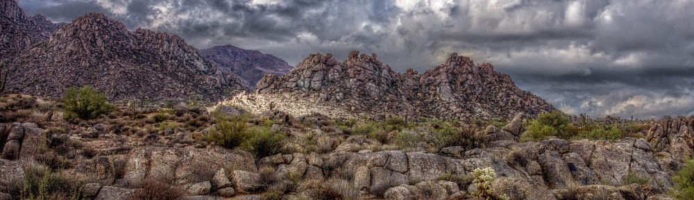
This was one of the interesting rock formations along the Marcus Landslide Trail.

Another interesting looking rock.  I posted another view of this rock yesterday.

This is a view from the Marcus Landslide Trail just prior to turning around.  Note that the trail keeps going and is visible in the lower right of the photo.

On our way back, we saw three equestrians on the Marcus Landslide Trail.

Here, Ranger Amy is telling us about the sound that a small type of squirrel was making as were hiking back.

Hiking along the Pemberton:

Nancy and Amy approaching the intersection of Pemberton and Bluff:

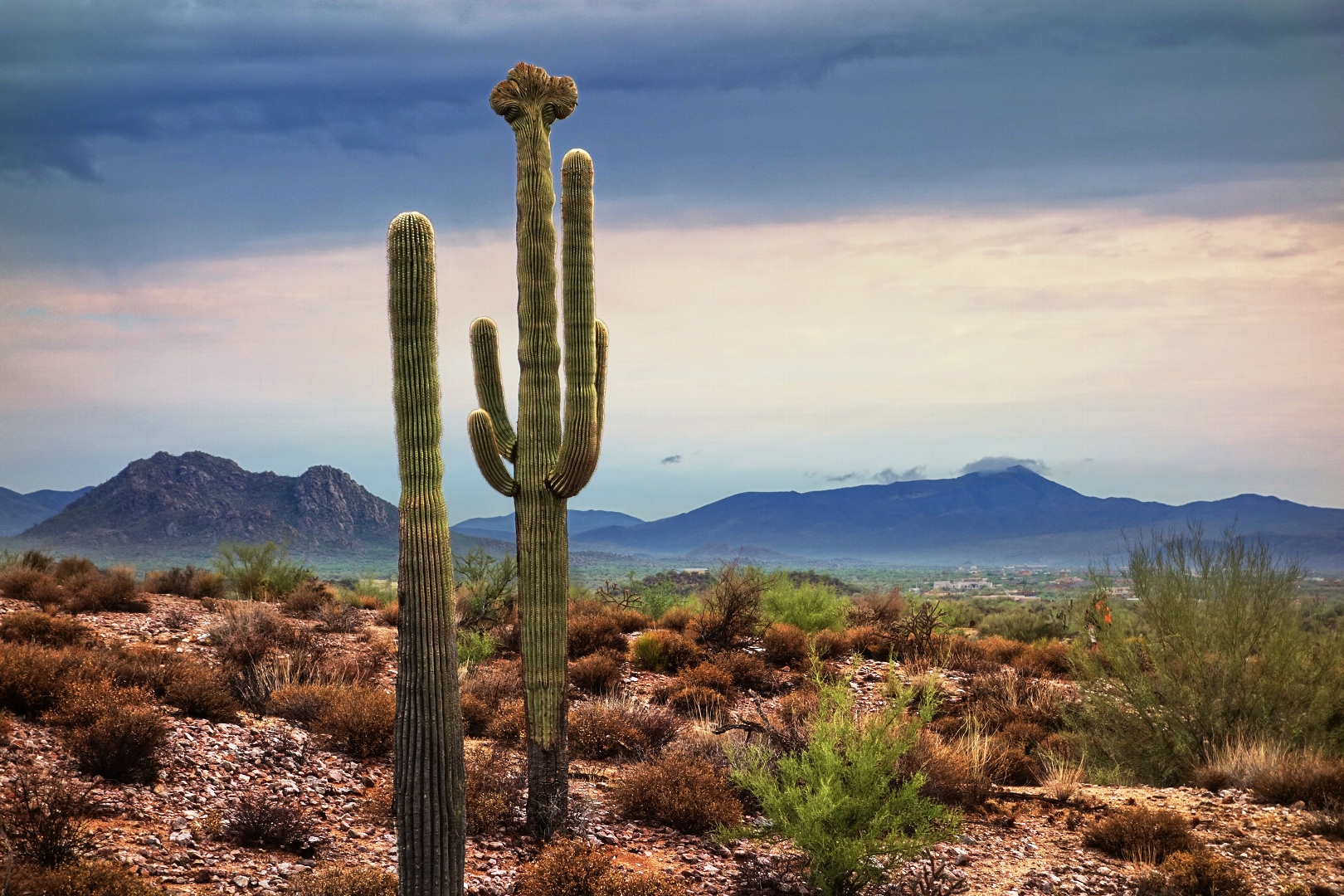
A very healthy saguaro on the Bluff Trail:

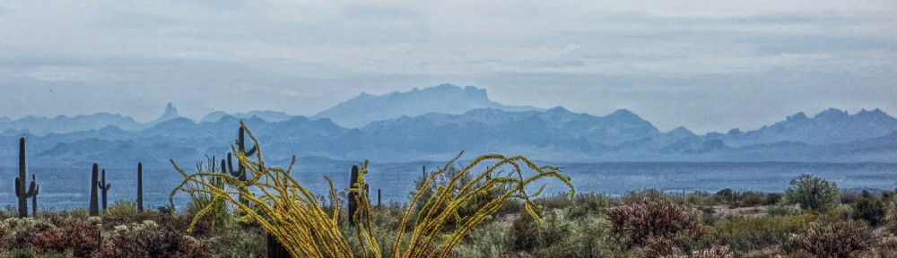
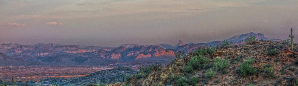
Ocotillo in the park had turned green from the recent rains, but the leaves are now drying out and turning yellow.  This one caught my eye as we were hiking back along the Bluff Trail.  Weaver’s Needle is visible along the skyline to the left.

We encountered three more equestrians while hiking down the Bluff Trail.


Fitness Hike Preview

I went out this morning and biked a potential route for tomorrow’s hike.  The photos below were taken from the McDowell Sonoran Preserve.

The Preserve trails have been diverted somewhat and sanitized since I was last there.  There are also some new trail signs.

Those leaning rocks on the skyline about a third of the way over from the left edge of the photo can be seen from many places in the park.  I sometimes think that they look like people hiking with heavy packs.

Another cool looking rock on the Marcus Landslide Trail:

It doesn’t say so on the sign, but this (below) is one end of the Boulder Trail.  The trail has been around for quite awhile, but only recently has an official opening been made in the fence.

Hiking the Dixie Mine Trail with Marilyn and Joe

Joe, Marilyn, and I went out late Sunday afternoon and hiked out a ways on the Dixie Mine Trail.

There were several contrails that hung around for the duration of our hike.  Here’s a photo where they seem to form a “V” emanating from behind one of the McDowells.

Weaver’s Needle is off in the distance in the photo below.  You can also see a part of Dixie Mine Trail in the foreground.  It’s a nice trail in that section.  There’s not a lot of elevation gain or loss, but numerous small hills and washes give texture to the terrain.

The half-moon and a nearby saguaro:

A particularly scenic section of the Dixie Mine Trail:

Mother and son hiking together just after sunset.

Another view of the contrails as the sun was setting:

A short while later, we turned to see that the setting sun had turned the contrails a brilliant reddish orange:

Another edit of the above photo using the Mantiuk ’06 contrast mapping algorithm.  All of the above photos use the Mantiuk ’06 contrast equalization algorithm.  In the tests that I’ve done, contrast mapping seems to produce more realistic looking results, but I often like the look obtained using contrast equalization.  The sky in the photo below is fairly close to the image obtained out-of-camera, but the out-of-camera foreground detail is very dark; so dark in fact that it appears to be mostly black.