Month: December 2012 (page 2 of 2)

Deer Creek, South Fork

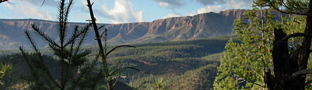
Bob, Janet, Allen, Nick, Linda, Marilyn, and I hiked the South Fork of Deer Creek on Sunday.  It had rained for on Thursday, Friday, and Saturday.  We saw on many of the mountaintops on the drive up.  Both forks of Deer Creek are often dry, but the South Fork was definitely not dry on Sunday.  Flowing water made hiking somewhat more difficult because the trail crosses the creek a number of times.  In dry conditions, it is possible to hike up the creek bed in many places.

Marilyn took these shots of snow in the mountains at the start of the hike:

This photo, also from Marilyn, shows the wet and rocky conditions in the creek.  There were big rocks all the way up the creek.  We often stepped from rock to rock while fording the creek.  I was happy that I wore my Gortex lined boots.

Another photo from Marilyn showing the running creek:

A dead tree that we saw along the way.  The Willow Fire ravaged the area in 2004.  The trail was obliterated as a result of erosion that occurred after the fire.  The trail was in good shape when we hiked it on Sunday though.

Another view of the trail before it dipped down and zig-zagged across the creek:

Another view of the creek.  In many places, the creek bed was lined with those big rocks.  I  had difficulty hiking on the uneven terrain.

From time to time, the trail left the creek.  I was surprised to find this expanse of golden yellow grass.

These red seed pods in front of another dead tree caught my eye.

Linda’s colorful gaiters:

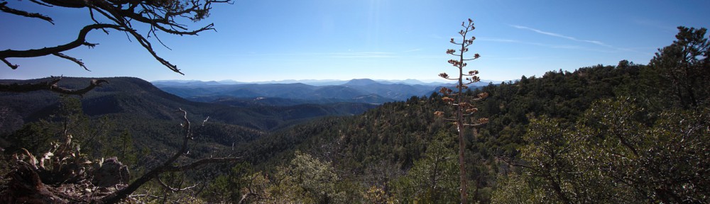
The white snow-capped peak in the photo below was visible for quite a long time as we hiked up the creek.  I thought it would continue to get larger and larger as we got closer.  It disappeared from view at some point though.  I don’t think we were able to see it again until we got far enough back on our return trip.

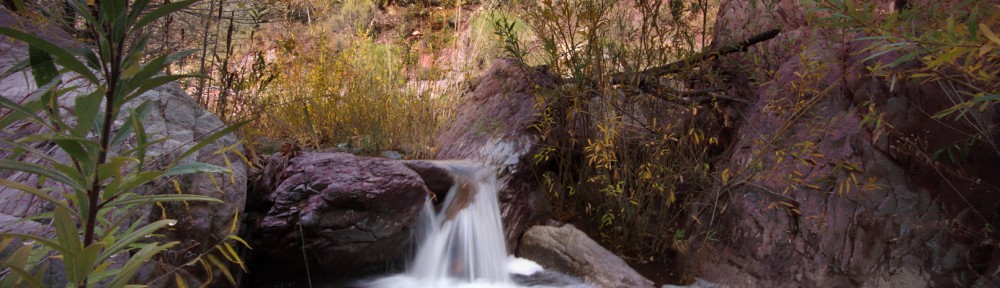
We saw several rapids, or perhaps miniature waterfalls, along the way.

I almost passed this one by, but everyone else was photographing it, so I did too.  I’m happy I stopped because I like this shot.

Linda hikes ahead of me, past a large red rock:

Janet, Linda, Marilyn, and Bob hike through one of many picturesque areas:

Marilyn readies her camera to take her own photos of this area:

Janet finds a way across the creek.  I lost count of the number of times we ended up crossing it.

Nick pretends to gnaw on a bone that he found.  Most of us stopped for lunch shortly thereafter.

I got this photo of some rapids as the rest ate lunch.

Janet hikes above another small waterfall.

The same waterfall with the Sun peeking through the vegetation:

I thought it was interesting to see stones intertwined with the roots of this fallen tree.

Nick rests by the creek while the rest of of catch up:

Linda, Marilyn, Nick, Janet, Bob, and Allen pose alongside and behind some cattails.  Apparently, the brim of my hat made it into the photo too.


Friday Fitness Hike

Today’s hike started at the Wagner Trailhead.  We went out Wagner, turned right on Granite, and turned up Delsie.  We then made our way back on Stoneman Wash and retraced our steps back to the trailhead.  We had a small group today, just me, Bob, Janet, Amy, and Lynn.  It had rained overnight and, although we got rained on a bit during our hike, it was clear most of the way.  The trails were very spongy though.

We saw these saguaros just off the Delsie Trail:

Amy holds up a horseshoe that she found in Stoneman Wash:

A mushroom shaped rock near Stoneman Wash:

Janet, Lynn, and Amy finish hiking Stoneman Wash:

A Hedgehog Cactus off the Wagner Trail:


Marie at her Band Concert

Below are a few photos of Marie from the Fountain Hills Middle School Holiday Band Concert.

Bear Flat Trail, 10+ years ago

It turned out that I and my family hiked part of the Bear Flat Trail back in late March of 2002. We made the same mistake then as we did on our more recent hike to the area; we hiked up the steep narrow path leading to the main part of the Bear Flat Trail.  Anyway, here’s what it (and we) looked like back then.  It doesn’t look that much different.  The kids, however, have changed a lot…

Hell’s Gate Wilderness: Bear Flat Trail / Mail Trail

Marilyn, Joe, Nick, and I hiked portions of the Bear Flat Trail and the Mail Trail in the Hell’s Gate Wilderness on Sunday.  My GPS showed that my total ascent was 2392 feet with a total distance of 6.64 miles.  Joe, Marilyn, and Nick went a somewhat shorter distance, doing portions of the Mail Trail twice, but perhaps going only to the halfway point along the Mail Trail.


View Bear Flat Trail / Mail Trail #178 in a larger map

Joe resets his GPS for the hike.  Marilyn and Nick are looking around in the distance.

We had to cross the Tonto Creek at the beginning.  We crossed by stepping on the rocks piled up from halfway up at the left edge of the photo.  Even though I tried to stay on the rocks, I still got some water in one of my shoes.

We turned the wrong way shortly after crossing the creek.  We saw a sign for the Bear Flat Trail and turned right.  We should have gone left, just past and above some private land with a house and a number of outbuildings.  The path to the right took us where needed to go too, but it was a lot harder.  It was a steep narrow trail with lots of switchbacks set into the side of an even steeper hill.  We gained about 400 feet of elevation in this short section of the hike.

Nick and Marilyn emerge from the short, but very steep section at the beginning of the hike:

At this point, we’ve all joined the actual Bear Flat trail.  (Joe is in this picture too, but is in the trees.)  The trail was fairly wide; I’ve read that it was once a jeep trail.

Tall trees on both sides of the trail provided some shade from the sun:

The trail eventually entered the Hell’s Gate Wilderness:

The Bear Flat Trail eventually left the Wilderness and forked off.  We explored the right fork for a while.  It lead to a couple of tanks, one of which was recently fenced off.  We lost the trail at that point.  It might have continued on the other side of the fence, but we would have had to cross the fence to do so.  That fork of the trail looked like an old logging road to me.

Below is a photo of some agave that I saw near one of the tanks:

We retraced our steps and explored the left fork, which headed more northerly.  After studying the GPS tracks, it is now clear to me that we were on the Bear Flat Trail when we encountered the fence and corral at the second tank.  The north fork that I took is signed as the Mail Trail #178 at its terminus.  The Bear Flat Trail also bears the #178 designation though.  I show a picture of the sign at the terminus later on.

Here is a view looking up at a dead tree that I encountered while hiking the Mail Trail #178.

A view looking back on the Mail Trail:

The trail passed a rock slide.  I clambered up on the lower portions of it to get a better view:

The trail was steep with lots of switchbacks.  You had to look carefully for some of the turnings of the switchbacks because it was easy to miss them.  To make matters even more difficult, there were cows in the area which made their own trails; cows don’t necessarily follow the switchbacks.  I startled a small group of cows at one point.  I only saw them briefly as they ran up the hill.  They were very fit cows.

The trail leveled off and went past a tree with a rusted metal disk attached to it.  I do not know its purpose.

The trail headed up again and the views got even better:

The trail topped out on a ridge with a bunch of dead trees:

From there, it was only a short way to the end of the trail where I took a photo of these trail signs.  I had just come from the direction indicated by the Mail Trail sign.  The other two arrows point up and down a road.  Hunter Creek Trail is up and Christopher Creek is down.

I turned around here because I had left the others and I feared that they might have started to worry about me.  (It turns out that they had.)

I took this photo of what I’m guessing is the Mogollon Rim from the clearing on the ridge:

This photo was taken while looking in a more southerly direction:

I got this photo as I was hiking back after rejoining the others.  The rim can be better seen in this photo.  You can also see the road that we drove in on.

Instead of descending the treacherous switchbacks with which we started our hike, we instead descended a relatively wide road lined with very tall pines:


Friday Fitness Hike

Friday’s hike started at the Trailhead Staging Area.  Eleven of us hiked the Scenic Trail and then a smaller group of us hiked out to the site of the ranch homestead.  We finished up by hiking back on part of Stoneman Wash.

Below is a group photo.  (There were too many new names for me to remember…)

Ranger Amy tells the group about a petroglyph that can be seen along the Scenic Trail:

Amy and Nick lead the way along the Scenic Trail:

A coil of barbed wire and a fence post remind us that the area was once a ranch:

The steep bank of a wash near the old homestead:

This clay pit (below) is just off the Pemberton Trail somewhat past the site of the old homestead.  I’ve been told that clay was mined here for a short period of time with the intent of making clay water pipes.  If it weren’t for the invention of PVC pipe, the area might have been very heavily mined for clay.

Four Peaks can be seen in the distance.

We saw some Desert Broom flowers that had gone to seed in some of the washes:

Hiking down one of the feeders to Stoneman Wash:

Hiking up a short, but steep hill leading out of Stoneman Wash:

The arrow points at Nancy:

Two of our hiking group with the McDowells in the background:


Avenue of the Fountains – Christmas Lights

Deer Creek

Joe, Marilyn, and I hiked Deer Creek Trail #45 on Sunday.  Joe and Marilyn hiked ahead of me and went a little over seven miles round trip.  I only went about five.  (I was busy taking photos.)

This is the south fork of Deer Creek just above the point where it joins Deer Creek’s main fork.

Fall color along Deer Creek.

A closer view of the golden yellow trees:

Another tree with the sun shining through:

Dead trees with new regrowth.  This area was ravaged by fire several years ago.

A rock along the trail.  I took this as I was heading back.

A small cacti.  I shot this at the lens’ maximum aperture of f/4 and maximum focal length of 18mm.  I was pleased with how well it blurred the background.

After sunset:

Friday Fitness Hike

Bob, Janet, Linda, Nancy, and I met at 7:30am, half an hour early, in order to give ourselves enough time to do a long hike with a significant amount of elevation change.  A 7:00am start might have been even better.

We hiked out Dixie Mine to the mine, passed the petroglyphs, and continued up the wash until we hit the Prospector Trail.  We took Prospector up to the Bell Pass Trail and then hiked up to Bell Pass.  After looking at the views afforded by our vantage point at Bell Pass, we turned around and hiked the Bell Pass Trail to the Windmill Trail.  We stopped at the windmill and spent some time looking around that area.  We continued on Windmill until it ended at Coachwhip. Coachwhip took us back to the Dixie Mine Trail, which, in turn, took us back to our vehicles.  We hiked twelve miles with over 1700 feet of total ascent.

Bob pointed out this bright field of quartz on the Dixie Mine Trail:

Linda takes photos of the petroglyphs near the mine, while Janet looks on:

Petroglyphs:

Linda hikes up the smooth and slippery rock of the (dry) waterfall while Nancy and Bob negotiate the bottom section.  It’s not really as far down as it looks in this photo; it’s an illusion created by the wide angle lens I was using.  If you look to the far left, you can see another petroglyph.

This is what it looked like from the bottom:

Linda, Janet, Bob, and Nancy slightly past the waterfall area.

Saguaros on the Prospector Trail.   The saguaros are “leaning” due to the fact that I was pointing the wide angle lens slightly upward.  I had thought about trying to correct the lean in post processing, but Marie convinced me that the photo looked cooler left alone.

The windmill, for which the Windmill Trail was named:

This large cottonwood is near the windmill.  It makes for a better landmark than the windmill itself since the windmill can be kind of hard to see from the Windmill Trail.

Another view of the cottonwood and the bullet-ridden storage tank:

Looking up through the dead tree at the right in the previous photo:

A view from the Coachwhip Trail.

Another view from further down the Coachwhip Trail:

Bob, Janet, and Linda pass the turnoff to the mine on the way back: